The Harbors of Caesarea Maritima
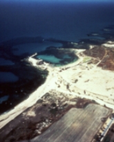
Aerial Photo of the Caesarea Harbor
Underwater excavations in Caesarea were first carried out in 1960 by A. Edwin Link. The expedition discovered the contour of the submerged Roman harbor, whose remnants were visible in aerial photos.
The AURI, led by E. Linder, excavated inside the harbor between the years 1963-1972. Since 1975, the site has been excavated by the CMS, directed by A. Raban with R.L. Hohlfelder, J.P. Oleson, R.L. Vann and R. Stieglitz, and in 1989 by A. Raban, K.J. Holum K.J. and E.G. Reinhardt.
The ongoing research project has exposed the entire Herodian harbor complex - Sebastos - comprising three basins: the open sea basin, which was constructed on imported building material; the intermediate basin, which was constructed on top of the kurkar ridge and the inner basin, which was partly excavated on land. Two towers were found, one on each side of the entrance channel, verifying the description of the historian Josephus. Still-intact quays and jetties on the northeast side of the intermediate basin and rock-cut and ashlar-built ship-sheds were also revealed.
The main moles were built with ashlar headers for the quays and large blocks of hydraulic concrete cast within prefabricated wooden barges. Excavations revealed the quays that encircled the inner basin, its flushing channels and a series of later renovation attempts that functioned up to the Byzantine period.
Several shipwrecks were found on top of the main breakwater of Herod's harbor and around it. These included part of the wooden hull of a large merchantman dating to 18-15 BCE that was carrying building materials and volcanic tufa from Italy, intended for the construction of the Roman harbor.
A submerged round Hellenistic tower that was associated with the Hellenistic anchorage of Straton's Tower was found within the intermediate basin of the Herodian harbor. Several stone-built quays and jetties dating to the Late Roman and Byzantine periods were found along the coast south of Caesarea.
Scholars have identified archaeological and geological indications for neo-tectonic activity in the Caesarea region. In particular, ruins of the western section of the Herodian Roman harbor are submerged to a depth of 5-6 m below sea level. It was suggested that a post-Roman neo-tectonic fault trending North-South is responsible for the subsidence of the harbor. Other scholars suggest that both archaeological and geological evidence indicate that the Caesarea region has been tectonically stable over the last 2000 years. The latter suggested that the western section of the harbor was built on top of unconsolidated sediments and later underwent settlement due to marine erosion.