Documentation of the Old City Walls of Jerusalem and Their Mapping By Means of Three Dimensional Laser Scanning
|

|
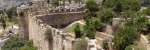
From April 2006 to November 2008 the Mabat - 3D Technologies Company, Ltd. conducted a complete and thorough scanning and measurement of the city walls. The detailed three dimensional scanning of Jerusalem's Old City walls provided the conservation planners of the Israel Antiquities Authority with up-to-date information prior to commencing work on each section of the walls.
There are two other important advantages to this mapping:
1. This is an updated documentation of the Old City walls, which is of historical value. The information itself will make possible future research projects and new studies.
2. The information collected on the wall will enable monitoring and tracking the wall's movement or parts of it, whether due to the ravages of time or as a result of a one-time event such as an earthquake. The Mabat - 3D Technologies Company, Ltd. previously carried out similar monitoring in the southeastern corner of the city wall.
As is the case in all planning work that is done on an existing structure, the planners required a complete mapping and documentation of the wall's facades and its upper part, wherever it could be done. The mapping serves as raw material for the planners in their work and the more reliable and detailed it is, the easier it will be to carry out the planning which in turn will become more relevant.
Since the wall is a large and complex monument with different geometric textures that are difficult to access, particularly on the inside, and because detailed documentation was needed at the level of the individual stone, it was suggested that the mapping be done using an innovative method known as 3D Laser Scanning (3DLS). Laser scanning allows three dimensional mapping and documentation, done from afar and without any contact, at an extremely high level of detail and precision, as well as measuring distances and coordinates of the documented entity. This technique was found to be extremely accurate and it provides excellent tools for planning and analysis.
This method of documentation was brought to Israel in 2000 by the Mabat - 3D Technologies Company, Ltd., which has been implementing it in a variety of engineering, architectural, industrial and artistic areas, among them the conservation of monuments, buildings and archaeological remains.
The Israel Antiquities Authority is among the pioneers using this innovative technology in the country. The IAA is one of the first institutions in the world to utilize this technique in conservation projects. The documentation and mapping of the Old City walls by means of laser scanning is unique in both its scope and the manner in which the information is used. This is considered a relatively large project in three dimensional scanning.
The system is based on a computer controlled device positioned opposite the measured environment which is sending thousands of laser pulses per second, while scanning the documented area. Each pulse is sent at a vertical and horizontal angle. The transmitted pulses strike the outer surface of the mapped object and are returned to the scanner which uses them for calculating the distance to the strike point. By knowing the distance and the two perpendicular angles, the spatial location of the strike point (X Y Z) and its color (R G B) can be derived.
In this way a very large collection of points, referred to as a cloud of points, is obtained which contains all of the geometric and visual information on Jerusalem's city walls. The cloud was acquired on the national coordinates grid. The scanner passed between hundreds of view points along the wall, and in that way the wall was scanned on both sides. The cloud of points was used as raw material in producing a three dimensional model of the city wall, cross-sections, drawings and plans, and for geometric analyses.
As previously stated, the wall's facades were documented by laser scanning. However the top of the wall, that is the promenade and the entire built complex on its upper part, was measured conventionally and the data was integrated as a three dimensional model in the cloud of points. Since the Old City's gates were considered of paramount importance they were therefore documented on the inside and outside in greater detail (at least one point every 8 mm); while the rest of the areas were documented with a minimum density of one point every 15 mm.
The data submitted to the planners enabled them to conduct a precise analysis of the state of the structure: to examine the inclination of the wall, bulging, settling of the entire wall or just a number of stone courses, missing mortar from the stone joints and much more information. The ability to make a cross-section and a localized study everywhere along the wall, including the decorative elements and the gates, provided a reliable tool for conservation planning.
The processed data made it possible for the planners to draw up work plans and familiarize themselves precisely with all of the components of the horizontal course of the wall
A Few Numbers:
- The wall's facades were scanned for a total length of 6,570 meters, of which 4,200 meters are on the outside; the remainder is on the inside of the wall. These constitute approximately 72,000 square meters of stone walls.
- The minimum scanning density on the facades was c. 15 mm or 4,400 points per square meter, without overlapping. In actuality there was between 35% - 70% overlapping in the scans.
- The planners received approximately one billion (1,000,000,000) points of information on the facades' surfaces.
- The total stored volume of the geometric and color information is 50 gigabytes.
- A total of some thirty work days were invested in scanning, including nine nights.
- About another twenty work days were required to complete the mapping of the promenade on top of the wall.
|
|

|
| Armenian Wall Section |

|
| Zahal Square Section
|
|