| The Dung Gate Section |

|
Historic Overview:
The area where the Dung Gate section is situated was first included within the city limits in the period of Nehemiah , with the Return to Zion at the end of the sixth century BCE.
In the Roman Period the Tenth Legion's camp was located at the foot of the southwestern corner of the Temple Mount, east of the Dung Gate. The route of the city wall and elements making up the legion's camp were uncovered in excavations conducted by Kathleen Kenyon (1965) and Benjamin Mazar (1971).
In the Byzantine period the city expanded to the south and its wall encircled the City of David and Mount Zion. At the same time the city's longitudinal axis, that is the secondary cardo - Cardo Valensis (the 'cardo in the valley') - ran through the region of the Tanners' postern. Remains of this road's pavement are today visible below the postern gate (M. Ben-Dov 1983). The Cardo Valensis began at the Damascus Gate, served the city's lower neighborhoods and came to the fork leading to Mount Zion and to the Pool of Siloam. The cardo is depicted on the Madaba Map as a wide street, with a single row of columns.
In the Early Islamic period the Umayyads built a government center, palaces and very large buildings south and west of the Temple Mount. Remains of these structures still exist in the archaeological garden inside the city wall. No changes were made to the city walls until the Crusader period.
In the Crusader period the walls were breached. Several years after the city was conquered its walls were rebuilt and they now included gates, towers and fortresses. The route the Crusader fortifications followed along the southern city wall is not known for certain. It is commonly believed that the route is identical to that of the Ottoman city wall we are familiar with today. Three gates were fixed in the southern wall. One of them was the Tanners' postern, which was situated at the end of the main road. This road preserved the route of the Eastern Cardo (the secondary cardo?) from the Roman period.
In the Ayyubid period period the fortifications were rehabilitated following the conquest of the city by Saladin.
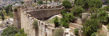
Along the south wall, between the Dung Gate and the Sulfur Tower, sections of a well preserved medieval wall and towers were exposed in excavations conducted in the 1970s under the direction of M. Ben-Dov. One of the towers was discovered beneath the Tanners' postern.
In the Ottoman period, the route of that period's city wall is thought to have followed the route of the wall from the Aelia Capitolina period. The city shrank in size along its southern flank; however, the route of the wall is not known for certain. It is also possible that no wall was situated in this region at all.
On the eve of the Ottoman conquest the southern wall stood in ruins. With the occupation of the city and rebuilding the walls, much work was required on this city wall. The new line was constructed along that of the medieval wall (the Ayyubid and Crusader periods). The route of the wall was then identical with that of the earlier walls; hence it is difficult to date the remains precisely.
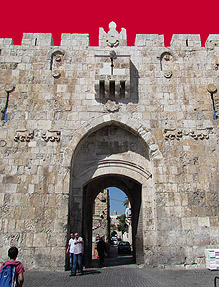
The second gate is the Dung Gate, also called the Mughrabi postern. It is one of two postern gates that were built in the wall in addition to the four main gates. The postern is located c. 20 meters from the Tanners' postern of the Ayyubid period. The reason for this apparently lies in the fact that the main street that led out of the city was moved to the east and the gate was erected at its end.
In the first half of the nineteenth century CE the gate was mainly used by pedestrians and the amount of traffic passing through it was light. Later it was opened for a number of hours a day for the purpose of transporting water, and it was only in 1865 that the gate was opened permanently. The Jews called the gate the Dung Gate after the southern gate from the period of Nehemiah. The origin of the Arabic name of the Mughrabi postern: "Bab al-Mughrabiya" - the western/Mughrabi gate, was given it because of its proximity to the Mughrabi neighborhood.
Dung Gate underwent numerous changes over the years. At first this was a narrow Ottoman postern for pedestrians and an inner gate tower. During the Ottoman period, the inner gate tower was demolished, and toward the end of that period an outer gate tower was constructed similar to the medieval fortifications. Along with building the outer tower, the arrow loop was opened above the gate and it became the entrance to the tower.
At the time of the British Mandate the city wall was rehabilitated and the outer Ottoman tower was dismantled. This intervention was probably a result of the policy requiring the removal of later additions from the monument.
In the Jordanian period the gateway was widened to allow vehicles to pass through it. The original Star of David ornamentation at the top of the gate, which was dressed in the stone when the wall was built by the Ottomans, was vandalized presumably because it was a Jewish symbol identified with Israel.
Following the reunification of the city after the Six Day War, the gate structure was renovated and the straight lintel in its opening was replaced with a low curving lintel.
References:
Ben-Dov M. 1987. The Tanners' Postern in the Middle Ages and the Mughrabi Postern in the Ottoman Period. Qadmoniyot 20. Jerusalem.
Kenyon K.M. 1967. Jerusalem, Excavating 3000 Years of History. UK.
Mazar E. 2003. The Temple Mount Excavations in Jerusalem 1968-1978 Directed by Benjamin Mazar, Final Reports Vol. II: The Byzantine and Early Islamic Periods Jerusalem.
|
|

|
| Orientation map |

|
| 1. View of the gate's inner facade, 1905. |

|
| 2. View of the gate tower at the time of the British Mandate (IAA Archive). |
|