| Conservation of the Dung Gate Section |

|
|
During February-June 2011 conservation measures were carried out along the Dung Gate section of the Old City walls. The measures were undertaken on behalf of the Israel Antiquities Authority and underwritten by the Prime Minister's Office and the Jerusalem Development Authority. The work was directed by Eran Hemo, with assistance from Yoram Sa'ad (professional guidance) Avi Mashiah, Yuval Avraham and Tamar Nativ (planning), Ofer Cohen and Yael Rosenthal (engineering) and Avi Peretz (head conservator). |
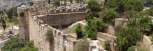
The Dung Gate section is located in the middle of the southern city wall, on the eastern side of the archaeological park and the western side of Bet Ha-Shalom Park. The Dung Gate is located in this section and nearby, to the west, is the Tanners' Postern, which dates to the Crusader Period (Figure 1). The Ottoman wall in this section is built on the foundations of fortifications from the Ayyubid period.
Physical Data
This section is 82 meters long. The outer facade covers an area of c. 1,150 square meters and the inner facade an area of 850 square meters. The outside of the wall ranges from 9 to 19 meters high whereas the inside is 3.5 - 17.0 meters high. An excavation conducted in the vicinity of the Tanners' Gate for the purpose of exposing the postern and the Eastern Cardo revealed the wall to its entire height. In the eastern part, in the place where the city wall promenade merges with Rehov Batei Mahse, there is a disparity between the height of the wall along the outer surface and the height on the inner surface.
Conservation Values:
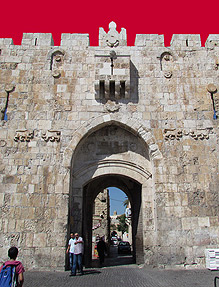
Historical Values.The Dung Gate wall and its surroundings are rich in architectural elements from many periods. Dung Gate was erected during the Ottoman period as a secondary gate to Zion Gate, which was the main gateway in the southern wall. At first it served as a small postern used by pedestrians and animals (Figure 2). The gate underwent far-reaching changes throughout the ages - from the Ottoman period, British Mandate and Jordanian rule - until it acquired its present form. Today this is a major gateway and allows vehicular access to the Western Wall plaza. There are remains from previous periods along this section of the city wall, among them the Tanners' Gate from the Middle Ages, which is used today as a secondary entrance for pedestrians. In addition, there are remains of the Byzantine cardo that was revealed beneath the postern. These are located in the Peace Garden.
Urban Values. The Dung Gate section of the city wall is important from an urban standpoint thanks to the two gateways in it for vehicles and pedestrians leading to the Old City and the flow of visitors to the Western Wall.
Architectural Values. Some of the changes the gate underwent throughout the ages are evident in the city wall. At first the gate was a low narrow postern that was used by pedestrians and animals. A gate tower and sentry post were located on its inside. The foundation stones of the covering vault in the sentry post have survived on the inside of the city wall. The outer gate tower that was constructed at the end of the Ottoman period existed very briefly (Figure 3). No traces of this tower are evident in the wall. Later influence dating from the Jordanian and Israeli periods is apparent in the gate's appearance today. During the Jordanian period the opening was enlarged and in the Israeli period it was redesigned as an arch-shaped opening, and it allows direct vehicular access to the city and the Western Wall plaza.
Physical Problems:
The inside lower courses of the city wall were placed on top of exposed foundations that are unstable. This notwithstanding, the city wall is well preserved. The disintegration of the lintel stones was identified in the Dung Gate structure and later intervention utilizing cement and steel which accelerate the stone deterioration was also noted.
Widening the gate to allow vehicles and buses to pass through has caused frequent damage to the gate's lintel, and in the wake of this wear and accelerated deterioration of the stone and the exposure of the iron rods that were installed in the opening after the Six Day War.
Conservation Measures
1. Reinforcing the ancient wall.The foundations of the Ayyubid city wall were reinforced east of the Tanners' Gate utilizing colored the shade of the original mortar from this period (Figures 4-5).
2. Controlling vegetation.
3. Stabilizing stone. Unsupported stones that were only held in place by mortar were found on the inside of the wall. The treatment included spraying vegetation with an herbicide and filling the joints with lime based mortar (Figs. 6-7).
4. The gate lintel. The intervention focused on preventing vehicular damage to the lintel stones. This was achieved by means of raising the center portion of the gate. The width of the segment that was raised was determined according to the dimensions of the ancient Ottoman gate. The cracked lintel stones were removed and a concrete casting was constructed in their place. The narrow dimensions of the concrete lintel made it possible to raise the opening, thereby reducing the possibility of vehicles striking the lintel (Figures 8-9). In this way improved functionality of the gate was achieved: a reduction in the damage caused to the opening's stones and preservation of the original gate's dimensions.
5. Completion of stone work. Cornerstones beneath the gate's decorative arch were found to be cracked and broken as a result of previous intervention utilizing concrete and steel. Their treatment included dismantling cracked stones, completing the stonework and reinforcing it by means of steel pins (Figs. 10-11).
6. The inscription field. An Ottoman Star of David, located above the opening, which was defaced in the Jordanian period, was highlighted by cleaning and delicate stone dressing (Figures 10-11).
List of Sources
Israel Antiquities Authority Archive: Mandatory Scientific Folder: File No. 79, Jerusalem City Walls and Collections.
|
|

|
| 1. The Dung Gate's facade after conservation, 2011, photographed by Yuval Avraham. |

|
| 2. The inside facade of the Dung Gate after the inner gate tower was removed, 1905. |

|
| 3. The later outer gate tower as seen from the south. British Mandate. Israel Antiquities Authority Archive. |

|
| 4. The city wall's foundations before conservation, 2010, photographed by Tamar Nativ. |

|
| 5. The city wall's foundations after conservation, 2010, photographed by Tamar Nativ. |

|
| 6. View looking southeast toward the inner facade of the city wall, prior to intervention, photographed by Tamar Nativ. |

|
| 7. View looking southeast toward the inner facade at the time of the work, 2011, photographed by Yuval Avraham. |

|
| 8. The lintel in the gate before conservation, 2010, photographed by Tamar Nativ. |

|
| 9. The lintel in the gate after conservation, 2011, photographed by Tamar Nativ. |

|
| 10. The decoration on the gate prior to the conservation, 2010, photographed by Tamar Nativ. |

|
| 11. The decoration on the gate after to the conservation, 2011, photographed by Tamar Nativ. |
|