| Zahal Square Section |

|
Historic Overview:
The section of the city wall known as Zahal Square is located in an area that was situated outside Jerusalem's city limits at the time of the First and Second Temples. The presumed route of the city walls during the Byzantine period did not pass through this area either.
It was probably only during the Umayyad period that the city wall followed this route for the first time, and where the Ottoman wall was erected hundreds of year later.
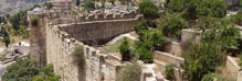
In 1971-1972 an archaeological excavation directed by Dan Bahat and Menashe Ben-Ari of the then Department of Antiquities was conducted there when preparations were being made for the Walls around Jerusalem National Park. During the excavation they discovered that the Ottoman wall was built on the remains of a tower that protrudes c. 3 meters from the line of the wall. The excavation of the tower's foundation and the area below it revealed that the structure was erected during the Middle Ages. The tower measures approximately 35X35 meters and is built of large stones in secondary use that are characteristic of Second Temple period construction. According to Muslim tradition this is where David slew Goliath the Philistine; hence the tower's Arabic name: Qasr Jalud. Europeans referred to the tower as Tancred's Tower because it was in this spot that Tancred breached Jerusalem's city wall in 1099. A street that separated the city wall from the tower passed to the north and west of the tower (Fig. 1). Researchers assume that the wall and tower, and probably the moat as well, were built in the Ayyubid period (1244-1260). A moat was hewn around the city wall which served as an additional line of defense protecting the city. During the excavation the moat was exposed to a depth of c. 7 meters.
In the Mamluk period the city wall probably ran along the same route as the Ottoman wall built by Suleiman the Magnificent (1535-1538).
In 1948 this section of the wall was the border between Israel and Jordan. Soldiers of the Jordanian Arab Legion built walls they could hide behind on top of the city wall, as they did in other sections of the wall that faced the New City.
References
Bahat D. and Ben-Ari M. 1972. Excavations in Zahal Square. Qadmoniot Volume V. Nos. 3-4 (19-20). Jerusalem. Pp. 118-119 (Hebrew).
|
|

|
| Orientation map |

|
| Fig. 1. Goliath's Tower and the moat surrounding it, relative to the line of today's city wall (from: Bahat and Ben-Ari 1972). |
|