|
|
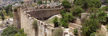
| The Citadel Walls |

|
Historic Overview:
The plaza in front of the Tower of David was constructed in 1535-1538. It is part of the system of fortifications that was built by the sultan, Suleiman the Magnificent. Cannons were deployed on the plaza, which is surrounded by a low crenellated wall. The glacis and the moat were built in a later phase of the wall's construction, in order to improve the defenses of the citadel. A deep ditch was dug around the plaza which created a peripheral moat that enclosed the citadel.
The northern part of the glacis which faces west was renovated some two hundred years later, during the rule of Sultan Mahmud I (1730-1754), following its collapse.
Physical Data
The citadel wall is c. 125 m long. The facade covers an area c. 1,215 sq m, of which 1,000 sq m belong to the sloped glacis (70 % inclination).
The outer face of the wall is 3 m high at its northern end and 11 m high in the southwestern corner. The average height of the wall's inner face is c. 1.7 m above the level of today's parking lot.
The elevation of the wall in this section is c. 772 m above sea level.
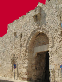
From the middle of the 1870's nearby Jaffa Gate became the main portal through which traffic flowed that arrived in the city from the west. The gate and the citadel became the symbol of the city thanks to their prominent location and distinctive shape. The region of the gate became a bustling place where tourism and commercial activities were concentrated. Two story buildings that were used as cafes and shops were erected outside the gatehouse. The road leading to Jaffa Gate was made wider in 1898, prior to the visit to Jerusalem by Kaiser Wilhelm II. At this time the moat located west of the citadel was blocked; over time it had filled up with refuse and was even used as a bed for vegetable gardens. Shops and houses were constructed in the open area that was created by the filled-in moat.
Excavations at the Site.Cedric Norman Johns, an archaeologist with the Mandatory government's Department of Antiquities, discovered the remains of arches from the Crusader period in the western and southern sides of the citadel during excavations he conducted there in 1934-1940. According to Johns this was the location of a rear entrance gate that passed above the Crusader moat to service areas that surrounded the Crusader hall (Johns 1950:184). This hall has survived until today. The plaza with the cannon emplacements which was excavated at that time has since been covered over.
Archaeological excavations were renewed in the citadel following the Six Day War. With the establishment of the Tower of David Museum, Rene Sivan and Giora Solar carried out additional excavations there in the 1980's. At that time service rooms that extend as far as the southern end of the glacis' wall were built beneath the plaza where the cannons originally stood.
The Crenellations in the Citadel's Wall.. Charles William Wilson, one of the pioneers of modern research in the Land of Israel and a head of the Palestine Exploration Fund, documented the citadel in 1865 (Fig. 1). We clearly see on his plan that the crenellations were not set at uniform intervals and that the embrasures were apparently determined according to the location of the gun emplacements. The crenellation intervals in the cannon plaza underwent further changes in the 1920's. In photographs that were taken at the beginning of the twentieth century we can discern the crenellations' dilapidated state of preservation (Fig. 2). Retaining walls were built in some of them (next to the northwestern tower) and others are clearly falling apart.
In the historical photographs from the beginning of the British Mandate the tops of the merlons in this section appear dome-like and were made of debesh and adorned with stone sentinels (Fig. 3). Today no traces of these domes are preserved. When the citadel wall underwent rehabilitation during the British Mandate vegetation was removed from the glacis, the stonework that was missing from the glacis was replaced and the joints were pointed up with new bonding material. The crenellations were rebuilt this time at intervals that resemble those of the crenellations which are on the citadel wall (Fig. 4).
During the war in 1948 the Jordanians broke through the crenellations in the southwestern corner of the plaza. The Arab Legion soldiers utilized this breach in order to shoot at the nearby neighborhood of Yemin Moshe (Fig. 5).
References
Johns, C. N. 1950. The Citadel, Jerusalem: A Summary of Work since 1934. QDAP 14.
|
|

|
| 1. text |

|
| 2. text |

|
| 3. text |

|
| 4. text |
|
 |
 |
|
|
| Websites, text and photos © Israel Antiquities Authority |
Powered by teti-tu |
|
|