|
|
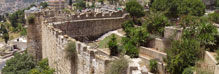
| The "Armenian Wall" Section |

|
Historic Overview:
First Temple Period. At the end of Nehemiah's period and in the Herodian period Jerusalem's city walls included the section known as the "Armenian Wall".
In the Second Temple period (first century BCE) Herod rehabilitated the city walls and their gates and the city expanded to the north. The walls enclosed the Upper City and Mount Zion. Herod made the Hasmonean wall thicker and renovated it; he built his palace in the southwestern corner and also opened a new gate in the wall leading to his palace.
After the Temple was burnt the Roman army advanced by way of the Lower City to the Upper City and from there to the fortress of David's Citadel.
Late Roman Period - Aelia Capitolina (135-326 CE). With the departure of the Tenth Legion from Jerusalem, the city remained unprotected and a wall was probably built around it. The southern part of the city decreased in size. We know from pilgrims' chronicles dating to the beginning of the Byzantine period that that Mount Zion and the Shiloah Pool were then located outside the city walls. Nevertheless, no evidence of a city wall from this period was found in archaeological excavations conducted along the line of the southern Ottoman wall. The Tenth Legion's camp, which remained in Jerusalem, was situated in the area of what is today the Armenian Quarter. The reason that no architectural remains or fortifications were found in that spot is that the camp was build of wood and tents.
Byzantine Period (326-638 CE). This was a time of prosperity and growth in Jerusalem; the city's population increased and numerous religious buildings were erected there. The route of the wall in the south was widened and it matched to a great extent the wall from the Second Temple period and included Mount Zion and the City of David hill. The line of the western wall, on the other hand, followed the previous route.
Early Islamic Period (638-1099 CE). The Byzantine wall continued to be used in the city in this period until the earthquake that struck in 1033 CE. This wall underwent extensive repairs and is described by the geographer, Muqaddasi, as a wall that included eight gates, five of which were in the southern wall.
Crusader Period (1099-1187 CE). The Crusaders rebuilt the city walls including their gates, towers and fortresses. The fortifications overlapped the Early Islamic wall. In the four corners of the city, fortresses were built for a multitude of soldiers and large amounts of munitions. Remains of one of the fortresses are still evident in the southwestern corner of the city wall.
Ayyubid Period (1187-1250 CE). Saladin conquered Jerusalem in 1178 CE. A number of years after the conquest, Saladin began rehabilitating the city walls and their fortifications - the city walls that had been neglected during the Crusader period. The wall at that time encircled Mount Zion and adjoined the Crusader fortress in the southwestern corner. In 1219 a great change occurred in the city, Jerusalem ceased to be a fortified city. It is widely believed that the Ayyubid ruler, Al-Malak Al-Mata'am 'Isa, destroyed the city's fortifications fearing the city would be conquered by the Crusaders.
Mamluk Period (1250-1517 CE). Although many argue that Jerusalem was an open city in this period, there is evidence from pilgrims that the city was surrounded by a wall that had gates. Remains of the walls that survived from earlier periods were destroyed toward the end of the fifteenth century, the eve of the Ottoman conquest.
Ottoman Period. During this period Suleiman the Magnificent rebuilt Jerusalem's city wall. The "Armenian Wall" section was erected toward the end of the city wall construction project. While the western city wall follows the earlier route based on the Second Temple wall, in the south the planners based the wall's route on the line of the Fatimid-Crusader wall, and therefore Mount Zion remained outside the fortifications. The route of the Ottoman wall which is known to us today probably follows the course of the wall from Roman period.
Jordanian Period. Until the city was unified in 1967, the city wall signified the borderline with Jordan. The Jordanians established fortified outposts on the wall's towers, the most important of which was "the corner outpost" in the southwestern tower. This position had a commanding view of the open area to the south and west, the road to Mount Zion and Yemin Moshe neighborhood. In the 1950's the area adjacent to the southwestern corner of the wall became a no-man's land.
The Jordanian outpost that was situated in this corner was built of stone and covered with a concrete slab. Because it was not possible to reach the Western Wall at that time, pilgrimages were only made to Mount Zion.
State of Israel. The excavation in the area of the southwestern wall and in the vicinity of the towers that led to Herod's palace was conducted in the early 1970's under the direction of Magen Broshi.
The Armenian Garden:
The area of the Armenian Garden was first inhabited at the time of Nehemiah, when the city sprawled out in that direction. In the first century BCE, the area was filled with soil that was retained by a wall and part of Herod's palace and residential buildings were erected on it. This wall collapsed during the first century CE, was rehabilitated and was breached again at the time of the destruction of the Temple in 70 CE.
This area was only resettled in the Byzantine period, in the sixth century CE, when the city flourished thanks to a massive influx of pilgrims who visited it. With the Muslim conquest in 637 CE, the place was abandoned and was only re-inhabited in the early thirteenth century CE, when the city was under Ayyubid rule. At this time a large khan was built for trade caravans that entered the city by way of Jaffa Gate. The khan existed for just a short period until the Crusader conquest.
In the late fourteenth century the Armenian community purchased the land there and they are still the owners of it to this very day. Olive trees and pine trees were planted in the area. A few buildings were constructed, mostly after the Ottoman wall was built (1537-1541). Apart from the Armenian Seminar building, which was erected in the twentieth century, no evidence of construction activity is apparent in the area.
We know from historical pictures that an olive grove that was there was removed in the early twentieth century; however, the use of the area remained agricultural.
In 1962-1967 extensive excavations were conducted there by the archaeologists De Vaux and Callaway, on behalf of the Baptist Theological Seminary in Kentucky. These excavations were later covered over and since then the area has been abandoned.
|
|

|
| Orientation map |
|
 |
 |
|
|
| Websites, text and photos © Israel Antiquities Authority |
Powered by teti-tu |
|
|