| Conservation of the "Ma'aleh Ha-Shalom" Section |

|
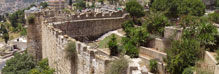
The "Ma'aleh Ha-Shalom" segment is located in the middle of the southern facade of the Old City wall. Archaeological gardens run the length of the segment and on both sides of it: Bet Ha-Shalom Garden on the outside of the wall and Ha-Tiqva Garden on its inside. Remains of fortifications from the Ayyubid period and remains of a corner of the Nea Church are among the antiquities that were uncovered at the foot of the Ottoman wall.
Physical Data
The "Ma'aleh Ha-Shalom" wall is c. 400 meters long and there are no gates in it. The wall's outer and inner facades cover an area of c. 5,000 sq m and c. 1,800 sq m respectively. The wall's skyline is stepped in accordance with the slope of the terrain. In the west the wall rises to an elevation of 757 m above sea level and in the east it reaches an elevation of 731 m; the difference in its elevations is 26 m. In addition, the outside of the wall is higher than its inside and ranges between 10 and 17 m. The inside of the wall is between 1.5 m and 10 m high.
Conservation Values:
Historical Values. The Ottoman city wall in the "Ma'aleh Ha-Shalom" segment was built along the same route as the fortifications of the Ayyubid period. The remains of the towers and the massive stone courses reflect not just the nature of the wall but also the importance of the city at that time. The remains of the Nea Church, situated beneath the Ottoman wall, are evidence of the structure of the city in the Byzantine period. Its boundaries at that time extended south of what is today the Old City. The church that was constructed at the end of the cardo was without doubt an important focal point in the city.
Urban Values. The "Ma'aleh Ha-Shalom" segment is an excellent observation point. It is also easily seen from afar. Its location in the middle of the southern wall, high above the slope that faces south and east, provided it with a commanding position over its immediate surroundings. In addition, thanks to the steep slope of the topography which descends south, this segment of the wall is much more visible than its environs. Because of this, the "Ma'aleh Ha-Shalom" wall has been portrayed in numerous paintings and drawings of the Old City that were done from the direction of the Mount of Olives located to the east. Although these works were meant to show the Temple Mount, they also include the "Ma'aleh Ha-Shalom" wall.
Architectural Values. The uniqueness of the "Ma'aleh Ha-Shalom" segment lies in the fact it is built on a sequence of remains from different periods, which are incorporated in the base of the Ottoman wall. These remains are an expression of the building technology of each and every period. The Nea Church stands out prominently with its massive dressed stone courses as befits the monumental construction in the Byzantine period. The remains of the Ayyubid fortifications are also made of huge stone courses. Their dimensions reflect the gravity of the threat to the city and the protection that was required at the time. As noted, the skyline, which is characterized by its stepped levels that drop off to the east, is the result of the topography but does not parallel it.
Physical Problems
When the promenade atop the city's battlements was being built in the 1970s and 80s conservation work was implemented that included pointing up the joints with mortar, completing the stone work along the outline of the wall and treating the roof level of the Sulfur Tower. However, in certain sections along the "Ma'aleh Ha-Shalom" wall it was apparent that stones were missing, mostly as a result of stone robbery, which was possible in those places where the ground is high on the inside of the wall.
The missing stone disturbed the regular spacing of the crenellations. Building stones that were in danger of becoming detached created a safety hazard all along the wall, and the interior of the Sulfur Tower was in a neglected and dilapidated state.
The archaeological remains close to the wall in the Peace Garden were covered with vegetation. Unstable stones were found in the Ayyubid fortifications and the Nea Church. Proper drainage between the horizontal surfaces and the Ottoman wall was never installed and this has resulted in water percolating into the built walls and a steady deterioration of their condition.
Conservation Issues
Restoring the Skyline. We had to address the issue of restoring the skyline in two places. The crenellated line in the tower above the corner of the Nea Church (Segment 104) was almost entirely missing. Based on the existing situation it was impossible to understand what the original crenellated line was. In another segment (No. 97) the skyline was disturbed because the embrasures in the crenellations were filled with later blockages.
In order to reach a decision regarding the crenellations and the skyline we required historical information about their original condition. In the case of the tower historical pictures were found that served as a basis for the decision to restore the line of crenellations (Fig. 1). This information made it possible to enhance the architectural value of the tower as an architectural component, and increase its urban value as an observation post positioned between the crenellations. In order that the skyline would be recognizable, it was decided to restore just one course of the original skyline based on historical information and not carry out a full restoration (Fig. 13). This made it possible to maintain the convenient observation point from the tower.
In the place where the merlons were filled in it was decided to leave them as they were and not intervene due to the lack of information that would allow a scientific restoration of the original skyline.
The Construction Phases of the Sulfur Tower (Fig. 2). Another issue that concerned us was the remains of the line of fortifications from the Middle Ages. Remains from different periods that are characterized by different kinds of stone courses and cores are situated beneath the Sulfur Tower. In order to conserve the tower dating to the Middle Ages we needed a better understanding of its components and its construction phases. In the Sulfur Tower we were asked to create clarity amongst the stone courses and the core, and clearly distinguish the seam between the tower dating to the Middle Ages and the Ottoman tower. A close examination of the stone courses showed that the position of the Sulfur Tower is apparently inflected relative to the tower at its base, and that its foundation courses are incorporated in the walls of the Ayyubid tower beneath it (Fig. 3).
Insofar as the conservation of the Ottoman tower is concerned we were asked to emphasize the difference in the construction characteristics of the remains of the Ayyubid tower, and thereby intensify how the various phases and the different periods are portrayed.
The Conservation Measures
1. Restoring the crenellations. In the tower above the corner of the Nea Church one stone course was restored in four crenellations; in the southern and eastern facades the restoration was done utilizing limestone. A crenellation that was missing stones was restored east of where the city wall meets the Nea Tower. The restoration was done because of the proximity of the crenellation to the tower (Figs. 4-10).
2. Mortar. . The base of the Sulfur Tower, which was erected on remains of an Ayyubid tower, is characterized by a combination of construction courses from different periods and the use of various kinds of mortars. In carrying out the conservation measures we matched the mortar to each construction period, in order to reflect the construction phases (Figs. 11, 12).
3. Debesh Construction. In the section of the Ottoman wall that was built on ancient remains we stabilized the wall by means of 'debesh' construction. The contact point between the 'debesh' construction and the wall was visually emphasized by applying mortar that is setback from the outer surface of the stone.
Sources:
Israel Antiquities Authority Archives: Mandatory Scientific Folder: File No. 79, Jerusalem City Walls and Collections.
Ashbee C.R. (ed.) 1921. Jerusalem, 1918-1920: Being the Records of the Pro-Jerusalem Council during the Period of the British Military Administration. London: J. Murray.
Wilson C.W. (ed.) 1880. Picturesque Palestine, Sinai and Egypt. London: Virtue.
|
|

|
| 1. The original crenellated line of the tower above the Nea Church, the southwest facade 1918-1920 (Ashbee 1921). |

|
| 2. Engraving. Looking south toward the roof level of the Sulfur Tower, 1840 (Wilson 1880). |

|
| 3. An illustration of the Sulfur Tower above the remains of a tower from the Middle Ages. |

|
| 4. The Nea Tower, inner facade in Segment 103 - before intervention. |

|
| 5. The Nea Tower, inner facade in Segment 103 - after intervention. |

|
| 6. The Nea Tower, outer facade in Segment 103 - before intervention. |

|
| 7. The Nea Tower, outer facade in Segment 103 - after intervention. |

|
| 8. The Nea Tower, outer facade in Segment 104 - before intervention. |

|
| 9. The Nea Tower, outer facade in Segment 104 - after intervention. |

|
| 10. An illustration of the roof level of the Nea Tower, looking south. |

|
| 11. Base of the Sulfur Tower prior to conservation. |

|
| 12. Base of the Sulfur Tower after conservation. |
|