|
|
| The Ma'ale Ha-Shalom Section |

|
Historic Overview:
The "Ma'ale Ha-Shalom section", which is located in the middle of the southern city wall, is called this because of its proximity to Ma'ale Ha-Shalom Road that runs parallel to the line of the wall. In the periods when the city expanded southward it was included within the city limits.
In the Second Temple period this area was included within the city's boundaries for the first time. At that time the wall enclosed the Upper City and the Lower City. The Ma'ale Ha-Shalom section was then situated in between both of these areas. In the "Bet Shalom" archaeological garden, located along the wall, remains were found dating to the Second Temple period, among them densely built dwellings, ritual baths and cisterns.
In the Roman Period. the city's borders shrank, particularly in the south. It is thought that the route of the wall in this period was the basis for the Ottoman wall; however, no evidence of this was revealed in excavations that were conducted there.
During the Byzantine period the city expanded southward again, and the route of the wall was similar to the route of the wall in the Second Temple period. The sixth century CE Madaba Map depicts the city in this period and the route of the walls surrounding it. According to the map, the wall hugs Mount Zion and the Shiloah Pool from the south and the Nea Church, which Justinian built, is shown within the city precincts.
The Byzantine city wall was also used in the Early Islamic period but repairs were made to it. In 1033 CE the region was struck by a powerful earthquake, in the wake of which the walls were destroyed.
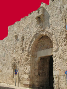
Crusader period. The Crusaders breached the city walls and following the capitulation a period of construction was begun in the city that included building the city walls and their gates.
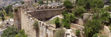
Ayyubid period. After conquering Jerusalem, Saladin reinforced the city walls. Along the Ma'ale Ha-Shalom section are the remains of three Ayyubid towers that were part of the city's fortification system.
Toward the end of the fifteenth century the city's southern wall was destroyed and stood in ruins until it was rebuilt by the sultan Suleiman in 1535.
Ottoman period. The Sulfur Tower, situated at bend in the wall, is incorporated in this section of the Ottoman city wall. An inscription affixed to the tower's southern facade shows that it was built in 1541, above the remains of a medieval tower (M. Ben-Dov 1983). In the western wall of the Ayyubid tower one can see the point where the Low-Level aqueduct enters it, which was built in the Second Temple period and also functioned in the Ottoman period. This aqueduct conveyed water from the Hebron hill country to the city.
Archaeological Excavations in the Resurrection Garden and the Peace Garden:
In 1970-1977 extensive archaeological excavations were conducted in the area of the Resurrection Garden (the name represents the rebirth of the Jewish Quarter from its ruins), together with the rehabilitation and construction activity in the Jewish Quarter. Excavations under the direction of Nahum Avigad were conducted along the southern wall between Zion Gate and the Sulfur Tower. These excavations revealed, among others, remains the Byzantine Nea Church, including its southeastern corner, apse and vaulted pool, which is located underground, below the level of the garden. In addition, remains of a gate tower dating to the Ayyubid period were discovered in the western part of the Resurrection Garden. At the same time as the excavations in the Resurrection Garden were being done, excavations were carried out along the outside of the wall in the Ma'ale Ha-Shalom Garden. These excavations were directed by Meir Ben-Dov prior to paving Ma'ale Ha-Shalom Road. The antiquities revealed in these excavations included cellars and ritual baths dating to the Second Temple period, a corner of the Nea Church from the Byzantine period and remains of medieval fortifications.
References
Ben - Dov M. 1983. The Fortifications of Jerusalem: The Walls, Gates and the Temple Mount. Tel Aviv: Zmora Bitan.
|
|

|
| Orientation map |
|
 |
 |
|
|
| Websites, text and photos © Israel Antiquities Authority |
Powered by teti-tu |
|
|